The administrative compound is located on a large tract of land belonging to the diocese. Before the war started, it was the center of a little outlying village, complete with the cathedral, seminary, catechists training center, priests house, convent, and bishop's residence. All of these buildings were damaged, some beyond repair, and abandoned during the war. The diocese is now in the process of rehabilitating those that are able to be salvaged, and is hoping to reopen the minor seminary on these grounds at the beginning of the next school year in early 2009. In the mean time, the diocese has loaned portions of its land to a number of different NGOs (non-governmental agencies) who are assisting in the rebuilding of the area. On the lot next to ours heading out of town is the compound of Caritas of Switzerland and Luxembourg, which supplies water and generator power to our facility. As I turn left out of our compound and head into town, I pass the plot being used by New Strength, New Hope, an evangelization outreach established by American missionary Katie Gesto, and now coordinated by two Ugandans, Steven Lugwana and Dennis Kiyimba. Following that (all on the left hand side of the road) comes the Catholic Relief Services (the international aid organization of the United States Catholic Conference of Bishops) compound - pictured below, followed by that of the Lutheran World Fellowship, Norweigan Church Aid and AVSI. Not for nothing has it been dubbed "NGO Alley."

On the opposite side of the road as we continue toward town, is the turn off (pictured below) that leads to the large UN peace-keeping compound. I'm not really sure exactly what all the UN does in Torit, but you always see large white Toyota Landcruisers and pickups painted with the large black or blue letters "UN" on the hood and sides, going back and forth along the main roads in town.

There are usually a lot of people walking back and forth along the road during the daylight hours, some coming into town from outlying villages, others - like the woman below - heading out of town to cut firewood. Like others I've seen before, this woman had an axe balanced on her head, and started to dance when I pulled out the camera to take her photo.

Along the road into town a lot of construction is taking place. There are many small round tukuls, topped with traditional grass thatched rooves, but also other buildings like the one below, which will be covered by mud and maybe cement, and has the benefit of a sheet metal roof.

Starting very early in the morning, and lasting almost all day long, there are women and children waiting to fill their jerry cans at one of the two wells or "boreholes" along the road. Drawing and hauling water, along with cutting firewood, is one of the daily time consuming chores necessary for life in Southern Sudan.

This is a large public school complex near the intersection with the main road coming from Kapoeta and the Kenya border. It has a main building with several free standing classrooms behind.

This is one of several cell phone towers that have been erected in the Torit area in the years since the signing of the peace accords in 2005. Cell phone coverage is spotty in Southern Sudan, and usually only found in larger population concentrations like Torit, Kapoeta and Juba, which is why many church, government and aid workers have satellite phones for communication in the expansive areas where cell phones don't function.

On the opposite side of the public school above is found a cluster of people who sell gravel for construction projects. They make the gravel themselves, pounding larger rocks into smaller stones using hammers, in order to generate a little income.

This is a photo of the parliament building - with flags flying in front - for Eastern Equatoria State, of which Torit is the capital. The entire country of Sudan is approximately one quarter the size of the US, for example from the East Coast up to the Mississippi River. Southern Sudan is about the size of the State of Texas. It is divided up into smaller states, such as that of Eastern Equatoria. In front of the parliament building is a large public soccer field.

This is the public hospital of Torit, run by the Ministry of Health. Like the public school above, it is comprised of a large main building, and several other free standing buildings in the back. The woman on the gound in front is physically handicapped and moves by crawling on her hands and knees.

This is the "roundabout," or traffic circle, where I turn left onto Main Street, otherwise known as the Torit-Juba road. I've never seen more than a few cars there at a time, but maybe someday the roundabout will be necessary to regulate traffic. To the right is a government building, and to the left a large public square named in honor of Fr. Saturnino Ohure, a leader in Southern Sudan's first liberation struggle who was killed in 1967, that is just now being landscaped.

After turning left at the traffic circle, on the left I pass the county jail. I've not yet had the chance to visit there, but am hoping to have the opportunity sometime soon. I can only imagine that the conditions are similar to those of prisons I've visited in Honduras and Jamaica.

This is one of many once-beautiful buildings in downtown Torit that were ravaged by the war. Some have been partially rehabilitated, but none seem to have recovered their original beauty.

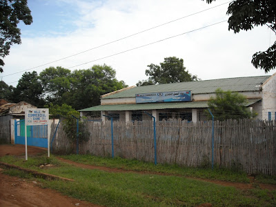
Below is the Nile Commercial Bank, the only one in town. It is rumored that other banks may open here soon, since Torit is the base for a lot of aid and development activity for this region of Southern Sudan.
Shortly after arriving in Torit I stopped in this pharmacy and asked whether they carried malaria test strips. The attendant nodded and showed me a box of test strips, but for syphilis not malaria. I told him that I didn't think I would need those, but if I did I would know where to find them. There was obviously a little language difficulty at work in the conversation.

This is one of two gas stations on the main street. There is at least one other a block or so above this one in the market area. Perhaps there are less than a dozen in the entire huge region between the border of Kenya and Juba.

The local mosque, from which the call to prayer is announced over loudspeakers several times a day. Islam's day of worship is Friday. There are a significant number of moslem merchants who have businesses in Torit.

A view of main street:

I had lunch at this Arabic restaurant (with the white wooden railing) with the German missionaries Daniel and Toby when I visited Sudan in June.

This is one of the surviving stalls from the former public market that was heavily bombed in air raids during the war.

This is the other gas station on main street. Almost right across the street is the bishop's residence and the diocesan offices. A little further down the street are the ruins of the parish church, my most frequent destination when I walk into town.

Although it's not directly on my way when I walk to church in town, I've included a few shots of the new public market, located two blocks above main street. These kinds of open shops are really the only kinds of stores in town.


1 comment:
I am doing research on a position with an NGO in South Sudan, and am starved for pictures of the region. Your site with the commentary and photographs is invaluable for someone like me who is trying to get a sense of the place.
Many Thanks!
Post a Comment